


Newbiggin Geology – Rocks and Landscapes
General Picture
The coastal fringe from Church Point in the North (Ordnance Survey Map Grid reference NZ317880) to just North of the mouth of the River Wansbeck at Sandy Bay (NZ303855) is almost entirely made up from Upper Carboniferous (now known as Pennine Middle Coal Measures Formation) rocks. These rocks are between 299 to 280 million years old.
However, except for the cliff faces, carrs , rocky shores and skerries, these Coal Measure rocks are overlain by Boulder clay or other superficial deposits such as sand. The Boulder Clay was brought from the North and North-west of the county under ice in the last glaciation. This is probably between 12-14,000 years old and is part of the North Sea Coast Glaciogenic Subgroup.
Between Church Point and Beacon Point (NZ316893) most of the bedrock is covered by Boulder Clay which in turn has been overlain by a glacial peat bed. This has for the most part been covered over by a layer of variable detritus from coal mining activities and dumping of other industrial waste reflecting the long industrial history of the area.
Upper Carboniferous Coal Measures Rocks/Pennine Middle
Coal Measures Formation
The rocks of this formation are best seen in Newbiggin between Spital Carrs (south end of the bay) NZ310870) to just north of Sandy Bay adjacent to the Northern edge of the Caravan park. (NZ305861 approx). Other exposures can been seen around Church Point and Beacon Point.
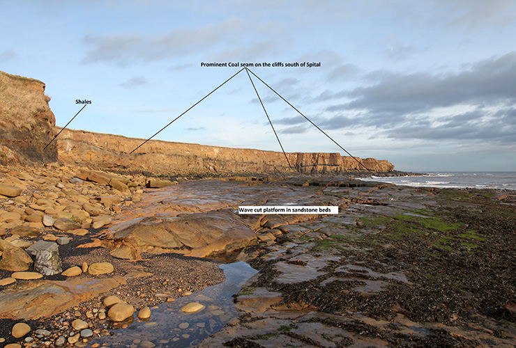
The rocks seen are a mix of sedimentary types. These include light grey brown or yellow brown sandstones, darker mudstones, silty thinly bedded mudstones and black shales., together with a prominent Coal seam. This Coal seam is present almost the whole length of the coast from just below the bungalows at Spital NZ310867) to where it is terminated by a fault on the coast just adjacent to the northern edge of the Caravan park. The coal is associated with a Seat-earth (fossilised soil) of variable thickness. Above it lies a substantial bed of hard sandstone known as the Seventy Fathom Post bed. The word “Post” is a miners’ term. Miners gave names to most of the sandstones and coals.
St Bartholomew’s Church is built from the Seventy Fathom Post sandstone. It was quarried locally and an in-filled quarry below the bungalows and industrial unit just south of the car park at Spital is a possible source, though other quarries have also existed in the past.
Closer examination of the sandstone bed in the cliffs reveals cross-bedding and ripple marks, both indicators of an ancient delta or coastal river system. In Carboniferous times, this part of Britain was found near the Tropics, so rainfall and temperatures were both high. On the banks of these river channels thick, luxuriant plants grew, including sizeable trees. For geological reasons, these river systems and deltas were unstable and were repeatedly flooded by the sea, thus burying the forests quite quickly. Over time, compaction of these forests has led to the formation of Coal seams. Below the cliffs, just south of the bungalows at Spital, freshly exposed fossil plants can be found, following a massive cliff fall. These fossilised plant remains can be seen on the faces of the bedding planes exposed on boulders below the cliffs. Some of the fossils are simply sooty patches of damaged leaves, others are substantial pieces of tree bark, branches or even tree trunks. They are around 290 million years old, and the rock fall means that they have not seen daylight since those times until today!
Huge Sigillaria tree bark fossil

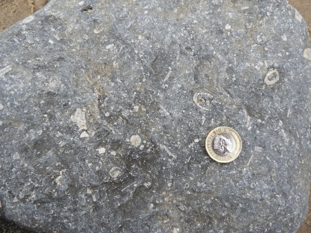
As the seawater flooded in, it sometimes became so deep that dark marine shales were deposited. As the sediments built up again to reach the sea surface (and the sea level fell at the same time due to geological reasons) the sediments became sandier and were largely deposited under fresh water. Sometimes the present day sea clears away boulders from the foreshore wave-cut platform to reveal an ancient bed of shales containing a fossil graveyard of many fresh-water mussels called Carbonicola. Eroded fragments of these beds can be found as small boulders and pebbles on Sandy Bay Spit. (See later).
Fossil tree bark of Lepidodendron aculeatum

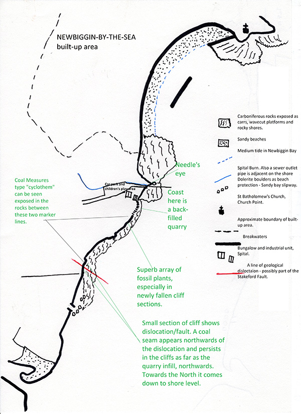
The repeated flooding by the ancient Carboniferous seas has led to the formation of repeated cycles of rocks, including Coal seams. This is why there are coal seams at different depths. These cycles are known as CYCLOTHEMS. At Newbiggin parts of two cyclothems can be seen in these cliffs. A good way to see them is to make the prominent Coal seam a marker horizon. It represents the top of one cyclothem.
The rocks below the coal seam are part of its cyclothem, but the rocks above it represent another cyclothem.
Fossil plant Stigmaria

All of this can be seen fairly well from the cliff path that runs to Sandy Bay from Spital. However, for those wishing to take a closer look at the rocks, clambering over very wet, slippery and awkward boulders at the foot of the cliffs is the only option. To do this you will need stout footwear with a good grip and possible a walking pole for balance. The best time to go is on a falling tide. There are only three access points: one at Spital, another an ill-defined scramble down the cliffs at the northern termination of the Caravan park, or via the sandy foreshore by means of the ramp from the caravan park, and then walk North on to the bouldery wave cut platform. The ramp is protected by large blocks of a dark igneous rock.
The Carboniferous rocks are dislocated by a fault, possibly related to the Stakeford fault, just below the northern edge of the caravan park. To the south of the fault, there is no Coal seam and the Carboniferous rocks are quickly replaced by boulder clay cliffs on which the majority of the caravan park rests. The difficult and dangerous bouldery foreshore gives way to a sandy and cobbly beach here.
Photo below of coast looking South

Recent Deposits
Boulder Clay
Leaving aside the detritus of human industrial waste which dominates the stretch of coast under the golf course between Church Point and Beacon Point, the most recent natural deposit is the Boulder Clay. Boulder Clay is left by ice sheets when they melt. It cloaks the landscape and contains, as its name suggests, boulders and pebbles of rocks which the ice eroded and picked up along the way. As the ice sheet travelled, it continued to break down these eroded boulders and the resulting deposit is a mix of different sized boulders, pebbles, grit and mud. These solid remnants tell us from which direction the ice came. In Newbiggin’s case, the boulders which are now washed out from the Boulder Clay are from North and North-west Northumberland.
Fossil Crinoid fragments in a Carboniferous aged limestone boulder. The source rock is from further N on the coast. This boulder has eroded out of the Boulder Clay. Found on Sandy Bay Spit apron.
They include Cheviot granite, Whin Sill dolerite, red sandstone, Carboniferous limestone with fossil corals, brachiopods and sponges and the characteristic fresh-water mussel graveyard rocks. The best place to find this wide range of rocks from the boulder clay is to visit the seaward apron of Sandy Bay spit where boulders, cobbles and pebbles of many of these rocks can be found. (NZ303854). This gives the observer a brief geological history of Northumberland! However, the industrial waste deposits have also been eroded by the current sea, releasing industrial materials such as bricks, concrete and other human-made material onto the spit’s apron.
Carboniferous age Fossil sponge, Syringopora, in a limestone boulder which has eroded out of the Boulder Clay.
Found on Sandy Bay spit apron. The source of this rock is much further North.

A pebble of Upper Carboniferous black shale with a graveyard of the fresh-water fossil Bivale Carbonicola.
Found on Sandy Bay spit apron eroded from a local exposure.

Sandy Bay Spit
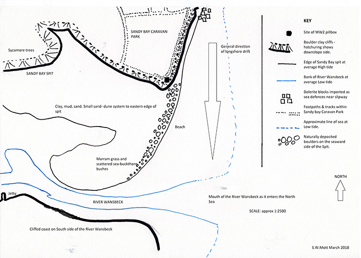
Sandy bay spit is a cuspate spit and is still being formed. This means that the distal end (the end furthest from the caravan park cliffs) curves in towards the channel of the River Wansbeck and affords a little protection to the muddy and sandy shore upstream of it. The energy of the sea exceeds that of the river, so it moves and shapes the end up river.
The proximal end (the end attached to the Boulder Clay cliffs of the caravan park) is more in line with the general trend of the coast. The boulders making up the apron here are generally larger than those at the distal end – this indicates that longshore drift is North to South. Longshore drift is the prevailing sea water current running parallel to the coastline.
The further the boulders or other deposits are moved, the smaller they get owing to further erosion. So this is why we can establish that long-shore drift is North to South on this coast.

The boulder apron of the seaward side of Sandy Bay Spit.